
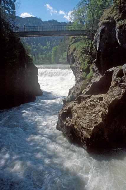
Bei der Tiefentalbrücke beginnt die letzte Etappe des LechErlebnisWegs.
-
Aufstieg: 65 hm
-
Abstieg: 40 hm
-
Länge der Tour: 13,8 km
-
Höchster Punkt: 813 m
-
Differenz: 33 hm
-
Niedrigster Punkt: 780 m
Schwierigkeit
mittel
Kondition
mittel
Panoramablick
viel
Saisonale Eignung
-
JAN
-
FEB
-
MRZ
-
APR
-
MAI
-
JUN
-
JUL
-
AUG
-
SEP
-
OKT
-
NOV
-
DEZ
Merkmale Touren
Etappentour
Aussichtsreich
Einkehrmöglichkeit


Hier befindet sich auch


Schloss Hohenschwangau
Alpseestraße, 30, 87645 Schwangau, Germany
Die "Kinderstube" des jungen Ludwig ll.

Essen in der Nähe
"Essen in der Nähe" überspringen

ca. 6,4 km entfernt
Magdalena
Obere Dorfstraße 23, 86984 Prem, Germany
Ein wunderschöner Blumenladen mit einem recht großen Café lädt zum Verweilen und Genießen ein.

ca. 6,4 km entfernt
Bayerischer Weißwurst-Stadl
Flößerstraße 11, 86984 Prem, Germany
In einem gemütlichen "Weißwurst-Stadl" können Gäste frisch produzierte Weißwürste genießen.
Unterkünfte in der Nähe
"Unterkünfte in der Nähe" überspringen


ca. 7,2 km entfernt
Ferienwohnung Sebastian Gerstner
Röthenbachstraße 34a, 86984 Prem, Deutschland


ca. 8,4 km entfernt


Weitere Tipps in der Nähe
"Weitere Tipps in der Nähe" überspringen

ca. 1,1 km entfernt
Lechradweg - Barrierefreie Route von Roßhaupten nach Lechbruck
Am reifen Lech durch das voralpine Hügelland.
1:25 h 137 hm 142 hm 19,1 km mittel

ca. 1,6 km entfernt
Staustufe Roßhaupten am Forggensee
Forggenseestraße 100, 87672 Roßhaupten, Germany
Erste Lechstaustufe: Forggensee – Staudamm Roßhaupten

ca. 3,3 km entfernt
Auerbergland@venture-Route
Die Erlebnis-Radrunde zu Kultur und Natur um den Auerberg.
9:20 h 1047 hm 997 hm 128,0 km sehr schwer


Das könnte Dir auch gefallen
"Das könnte Dir auch gefallen" überspringen
Etappe 3, Nordschleife, Heilige Landschaft Pfaffenwinkel - Von Raisting nach Herrsching
Die dritte Etappe des Fernwanderwegs Heilige Landschaft Pfaffenwinkel führt uns von Raisting über Fischen an den Ammersee. Ein bisschen Zeit sollte man auf dem Weg von Raisting an den Ammersee schon einplanen, denn neben der eindrucksvollen Landschaft, die vor allem durch die weitläufigen Ammerwiesen, die Ammer selbst und natürlich dem Ammersee geprägt ist, gibt es auch einige Bauwerke und Museen zu besichtigen. So befinden sich zum Beispiel in Sölb die schöne Filialkirche St. Margareta, in Fischen die Maria-Hilf-Kapelle und das Kupfermuseum, in dem die Geschichte des Kupferhandwerks bestaunt werden kann, und kurz vor Herrsching schließlich da barocke Schloss Mühlfeld. Erholung bieten die zahlreichen Strandcafés am Ammersee. Hier kann man die Seele einfach mal baumeln lassen.
4:30 h 54 hm 74 hm 14,9 km mittel


König-Ludwig-Weg, 3. Etappe: Paterzell - Hohenpeißenberg
3:44 h 409 hm 333 hm 12,8 km sehr schwer

König-Ludwig-Weg, 5. Etappe, Variante: Rottenbuch - Trauchgau
5:22 h 243 hm 218 hm 20,5 km mittel


König-Ludwig-Weg, 6. Etappe, Variante: Trauchgau - Füssen
6:01 h 332 hm 332 hm 22,3 km mittel


LechErlebnisWeg
Wandern Sie durch die herrliche Fluss- und Seenlandschaft des Lechs. Natürliche Flussabschnitte, spiegelnde Seen, gemütliche Ortschaften und die historischen Altstädte von Landsberg, Schongau und Füssen bilden die malerische Kulisse dieses Fernwanderweges.
23:00 h 769 hm 496 hm 86,7 km mittel


Etappe 3, Ostschleife, Heilige Landschaft Pfaffenwinkel - Von Bernried nach Penzberg-Promberg
Die dritte Etappe der Ostschleife des Fernwanderwegs Heilige Landschaft Pfaffenwinkel führt uns von Bernried nach Promberg bei Penzberg. Das Highlight dieser Etappe ist der Weg entlang des Starnberger Sees. Wir genießen einen grandiosen Weitblick auf den See und das Alpenmassiv.
3:45 h 122 hm 98 hm 14,3 km mittel

Etappe 4, Nordschleife, Heilige Landschaft Pfaffenwinkel - Von Herrsching über Andechs nach Pähl
Von Herrsching wandern wir auf der vierten Etappe des Fernwanderwegs Heilige Landschaft Pfaffenwinkel durch das Kiental, eine bis zu 70m tief eingeschnittene Nagelfluhschlucht zum Kloster Andechs. Auf dem Weg nach Andechs tauschen wir das flache Gelände des Ammersees wieder gegen Wald, Wiesen und leichte Hügel. Man sollte sich genug Zeit nehmen, um das berühmte Kloster Andechs zu besichtigen und in der Klosterschänke einen guten Tropfen Bier und leckere regionale Schmankerl zu genießen. Die Geschichte des Klosters geht zurück bis in zehnte Jahrhundert und es ist dank aufwendiger Restaurierungsarbeiten heute noch sehr gut erhalten. Schweren Herzens sagen wir den Leckereien aus der Klosterküche Lebwohl, denn die Strecke führt uns weg vom Kloster Andechs und weiter nach Pähl. Der Ausblick über den Ammersee und die hügelige Landschaft des Pfaffenwinkels, die wir auf dem Weg erleben dürfen, entschädigt dafür aber allemal. Auch die kleine Hartkapelle, deren Geschichte einem kleinen Krimi gleicht und das Gut Kerschlach mit Hofladen, Bäckerei/Café und einem schön angelegten Klostergarten sind Highlights auf dem Weg. In Pähl selbst vor allem die St. Laurentius-Kirche sehenswert.
7:00 h 234 hm 187 hm 16,2 km mittel

Etappe 5, Nordschleife, Heilige Landschaft Pfaffenwinkel - Von Pähl nach Weilheim
Puste ist gefragt - die 21 km der fünften Etappe von Pähl über Wilzhofen und Marnbach nach Weilheim fordern unsere Ausdauer. Dafür werden wir mit vielen schönen Ausblicken über die herrliche Hardtlanschaft und teilweise bis zu den Alpen, Sehenswürdigkeiten sowie grünen Wäldern und Wiesen belohnt. Architektonische Highlights erwarten uns in Weilheim, darunter die Pfarrkirchen Mariä Himmelfahrt und St. Pölten und der Marienplatz sowie die gut erhaltene Stadtmauer. Auch das sogenannte "Museum des Pfaffenwinkels" ist ein Besuch wert. Dort werden Exponate der Region präsentiert und die Geschichte des Pfaffenwinkels näher beleuchtet.
7:00 h 305 hm 322 hm 21,3 km mittel

Etappe 5, Ostschleife, Heilige Landschaft Pfaffenwinkel - Von Benediktbeuern nach Iffeldorf
Die fünfte Etappe des Fernwanderwegs Heilige Landschaft Pfaffenwinkel Ostschleife führt uns von Benediktbeuern nach Iffeldorf. Auf dieser Etappe bestaunen wir das Kloster Benediktbeuern, die Heuwinklkapelle und die Kirche St. Vitus in Iffeldorf. In Penzberg wandern wir im Erholungsgebiet Berghalde auf den Spuren des Bergbaus und erfahren Wissenswertes zur Geschichte der Stadt Penzberg.
5:15 h 262 hm 277 hm 20,8 km sehr schwer

Etappe 6, Nordschleife, Heilige Landschaft Pfaffenwinkel - Von Weilheim nach Peißenberg
Die sechste Etappe des Fernwanderwegs Heilige Landschaft Pfaffenwinkel Nordschleife führt uns von Weilheim nach Peißenberg. Falls wir nach der langen fünften Etappe keine Zeit mehr hatten, Weilheim zu besichtigen, so lässt uns die nicht ganz so lange, sechste Etappe dafür genug Zeit im Vorfeld noch durch die Fußgängerzone und über den Marienplatz zu flanieren, die Stadtpfarrkirche Mariae Himmelfahrt zu besuchen und die Kirche St. Pölten - die älteste Weilheimer Kirche, deren Ursprünge bis ins 8. Jh. zurück gehen zu bestaunen. Danach machen wir uns auf den Weg nach Peißenberg. Unterwegs treffen wir erneut auf die Ammer und können in Polling das sehenswerte Klosterdorf (Kloster Heilig Kreuz) und die Stiftskirche St. Salvator der Augustiner Chorherren besuchen.
3:45 h 157 hm 141 hm 12,4 km mittel

Etappe 7, Nordschleife, Heilige Landschaft Pfaffenwinkel - Von Peißenberg auf den Hohen Peißenberg
Die letzte Etappe des Fernwanderwegs Heilige Landschaft Pfaffenwinkel führt uns über eine kurze, aber dennoch anstrengende Strecke zurück zu unserem Ausgangspunkt auf dem Hohen Peißenberg. Frische Beine sind beim Aufstieg zum Hohen Peißenberg sicher nicht schlecht, allerdings nicht unbedingt ein Muß, denn die knapp 6 km und 400 hm kann man auch ganz gemütlich angehen. Je höher wir kommen umso besser wird der Ausblick über den Pfaffenwinkel und wir können noch einmal die Region überblicken, die wir in den letzten Tagen zu Fuß erkunden konnten.
3:15 h 397 hm 3 hm 7,0 km mittel

Etappe 8, Ostschleife, Heilige Landschaft Pfaffenwinkel - Von Peißenberg zum Hohen Peißenberg
Die achte und letzte Etappe der Ostschleife des Fernwanderwegs Heilige Landschaft Pfaffenwinkel führt uns von Peißenberg auf den Hohen Peißenberg. Wir wandern auf abwechslungsreichen und wenig befahrenen Wegen auf den Aussichtsberg des Pfaffenwinkels, wo wir das Ziel des Fernwanderwegs erreichen.
4:00 h 409 hm 40 hm 8,9 km sehr schwer


König-Ludwig-Weg, 4. Etappe: Hohenpeißenberg - Rottenbuch
Diese Tagesetappe sorgt für ungeante Natureindrücke. Bitte die Sicherheitshinweise beachten!
3:45 h 191 hm 201 hm 12,8 km sehr schwer

Etappe 2, Ostschleife, Heilige Landschaft Pfaffenwinkel - Von Weilheim nach Bernried
Die zweite Etappe des Fernwanderwegs der Ostschleife Heilige Landschaft Pfaffenwinkel führt uns von Weilheim in Oberbayern nach Bernried. Weitläufige Moor- und Sumpfgebiete, idyllische Seen und malerische Wälder begleiten den Weg zum Starnberger See. Auf dieser Etappe führen uns die Vielzahl an Kapellen und Kirchen vor Augen, wie der Pfaffenwinkel zu seinem Namen kam.
5:45 h 212 hm 181 hm 22,5 km mittel

Etappe 4, Ostschleife, Heilige Landschaft Pfaffenwinkel - Von Penzberg-Promberg nach Benediktbeuern
Die vierte Etappe der Ostschleife des Fernwanderwegs Heilige Landschaft Pfaffenwinkel führt uns von Promberg zur Klosteranlage in Benediktbeuern. Auf dem Weg kann man die Kirche in Nantesbuch und die Filialkirche St. Georg in Bichl bestaunen, ehe eine der beliebtesten Sehenswürdigkeiten des Pfaffenwinkels erreicht wird.
3:45 h 56 hm 61 hm 13,7 km mittel

Etappe 6, Ostschleife, Heilige Landschaft Pfaffenwinkel - Von Iffeldorf nach Huglfing
Die sechste Etappe der Ostschleife des Fernwanderwegs Heilige Landschaft Pfaffenwinkel führt uns von Iffeldorf nach Huglfing, durch das wunderschöne Gebiet der Osterseen und durch dichte Wälder. Diese Tour verspricht viel Natur im Pfaffenwinkel.
5:45 h 386 hm 385 hm 25,7 km sehr schwer

Westschleife "Wilde Flüsse" - Heilige Landschaft Pfaffenwinkel
Drei Mehrtageswanderungen führen durch die schönsten Ecken des oberbayerischen Pfaffenwinkels, dessen Kultur über Jahrhunderte durch zahlreiche Klöster geprägt wurde. Die ruhigen Wanderwege verbinden Kirchen, Klöster und Kraftorte in der Natur. Die drei Pilgerwege starten und enden am Hohen Peißenberg, der einen Rundblick über die gesamte Region bietet und als bedeutender Wallfahrtsort dafür prädestiniert ist. „Wilde Flüsse“ - Ammer und Lech prägen die Landschaft der Westschleife. Die etwas kürzeren, aber hügeligeren und anspruchsvolleren 6 Tagesetappen mit 76 km verbinden Highlights wie die wild-romantische Ammerschlucht, den Brettleweg durch das Wiesfilz oder die Besteigung des Auerbergs mit den Klosterorten Rottenbuch, Steingaden und Schongau und den bedeutendsten Kirchen der Region u.a. dem UNESCO Welterbe Wieskirche.
21:01 h 1306 hm 1337 hm 76,0 km

Gravelbiken mit Zugspitzblick - Hoher Peißenberg und wilde Ammer (Weilheim-Schongau)
Auf dieser Gravelbike-Tour startest du in Weilheim, passierst die Erdefunkstelle Raisting, erklimmst den Hohen Peißenberg und entdeckst die idyllische Wilde Ammer bis nach Schongau.
4:50 h 865 hm 744 hm 66,9 km mittel


Gravelbiken mit Zugspitzblick - zwischen Lech und Ammergebirge (Schongau-Oberammergau)
Auf dieser Gravelbike-Strecke startest du in Schongau, passierst den malerischen Lech mit seinen Staustufen und folgst dem König-Ludwig-Weg durch Hügel und Wälder. Von Altenau führt die Route entlang des Ammertals, durch das Pulvermoos bis ins charmante Oberammergau.
4:10 h 466 hm 288 hm 56,4 km mittel