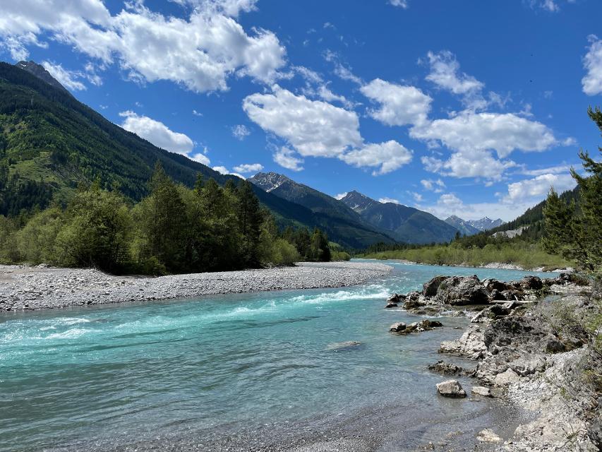
Willkommen am letzten Wildfluss Europas!
Aufstieg: 1160 hm
Abstieg: 474 hm
Länge der Tour: 239,7 km
Höchster Punkt: 1117 m
Differenz: 724 hm
Niedrigster Punkt: 393 m
Schwierigkeit
mittel
Kondition
mittel
Panoramablick
sehr viele
JAN
FEB
MRZ
APR
MAI
JUN
JUL
AUG
SEP
OKT
NOV
DEZ
Merkmale Touren
Fernradweg
Etappentour
Aussichtsreich
Kulturell / historisch
<p>Das Auto kann am Schwabenhallen-Parkplatz (P9 in der Karte, Ecke Gartenstraße / Neue Obermayerstraße) unweit des Bahnhofes abgestellt werden. Entweder geht es mit den örtlichen Bussen oder über den Donauradweg zum Startpunkt des Lechradwegs. Die Fahrradmitnahme ist jedoch begrenzt.</p>
Anreise mit dem Auto
Über die A7 bzw. die A9 und die Bundesstraße 16 nach Donauwörth.
Anreise mit dem Flugzeug
Allgäu Airport bei Memmingen, Flughafen München und Flughafen Innsbruck. Die Weiterreise per Bus beziehungsweise Bahn ist von allen Flughäfen aus möglich.
Anreise mit der Bahn
Am Lechradweg liegen auf deutscher und österreichischer Seite elf Bahnhöfe, was die An- und Weiterreise sehr flexibel macht. Mehr auf www.bahnland-bayern.de und www.vvt.at.
ÖPNV
Der Lechradweg ist gut an den Bahnverkehr angeschlossen. Die Mitnahme des Rades ist grundsätzlich möglich. Viele Nahverkehrszüge haben dafür ausgewiesene Mehrzweckabteile für Radler, auf die das Fahrradsymbol in den Einstiegsbereichen hinweist. Zur Mitnahme des Rades eine entsprechende Fahrradkarte lösen. Auch in vielen Regionalbussen ist die Mitnahme der Räder möglich. Zwischen Reutte und Warth verkehrt in der Hauptsaison (je nach Wetterlage meist Ende Mai bis Anfang Oktober)ein separater Rad- und Wanderbus mit Radanhänger für 38 Räder. Fahrpläne und -zeiten unter www.lechtal.at, www.reutte.com und www.vvt.at
Plane deine individuelle An- und Weiterreise für deinen Urlaub auf dem Lechradweg ganz einfach unter www.lechradweg.info.

ca. 0,0 km entfernt
Grüne Weite und geschichtsträchtige Orte
3:20 h 83 hm 6 hm 48,6 km sehr leicht

Auf einer Länge von 500 Kilometern verläuft derRadfernweg parallel zur Romantischen Straße aufschwach befahrenen Nebenstrecken,Ortsverbindungsstraßen, Flurbereinigungs- undWaldwegen. Der Radfernweg D9 „RomantischeStraße“ wurde vom ADFC 2013 mit 3 Sternenausgezeichnet und ist sorgfältig und durchgehendausgeschildert, als Rad-Weitwanderweg hat er sichin dieser Streckenführung seit den 80-er Jahrenbewährt.
32:37 h 2178 hm 1547 hm 496,5 km mittel

Bayerisch-Schwaben: Beliebter Fernradweg - Wo einst die Römer reisten...
12:00 h 727 hm 326 hm 172,5 km sehr schwer
Grüne Weite und geschichtsträchtige Orte
3:20 h 83 hm 6 hm 48,6 km sehr leicht

Seen, Auenwälder und Weltkulturerbe
3:10 h 132 hm 20 hm 46,4 km sehr leicht

Flößergeschichte, Hügelland und die Alpen im Blick
4:20 h 404 hm 263 hm 57,5 km mittel

Von den Voralpen in die Berge hinein
3:30 h 309 hm 133 hm 46,4 km mittel

Wilder Lech, imposante Berge und traditionelle Kunst
3:20 h 265 hm 17 hm 43,7 km sehr leicht

Pures Radvergnügen auf 418 km vom Bodensee zum Königssee!
31:24 h 2964 hm 2752 hm 441,2 km mittel

Fernradweg von den Ammerquellen bei Oberammergau über den Ammersee bis nach Moosburg an der Isar.
14:00 h 260 hm 714 hm 202,6 km sehr leicht

Puste ist gefragt - die 21 km der fünften Etappe von Pähl über Wilzhofen und Marnbach nach Weilheim fordern unsere Ausdauer. Dafür werden wir mit vielen schönen Ausblicken über die herrliche Hardtlanschaft und teilweise bis zu den Alpen, Sehenswürdigkeiten sowie grünen Wäldern und Wiesen belohnt. Architektonische Highlights erwarten uns in Weilheim, darunter die Pfarrkirchen Mariä Himmelfahrt und St. Pölten und der Marienplatz sowie die gut erhaltene Stadtmauer. Auch das sogenannte "Museum des Pfaffenwinkels" ist ein Besuch wert. Dort werden Exponate der Region präsentiert und die Geschichte des Pfaffenwinkels näher beleuchtet.
7:00 h 305 hm 322 hm 21,3 km mittel

Die fünfte Etappe des Fernwanderwegs Heilige Landschaft Pfaffenwinkel Ostschleife führt uns von Benediktbeuern nach Iffeldorf. Auf dieser Etappe bestaunen wir das Kloster Benediktbeuern, die Heuwinklkapelle und die Kirche St. Vitus in Iffeldorf. In Penzberg wandern wir im Erholungsgebiet Berghalde auf den Spuren des Bergbaus und erfahren Wissenswertes zur Geschichte der Stadt Penzberg.
5:15 h 262 hm 277 hm 20,8 km sehr schwer

Die sechste Etappe des Fernwanderwegs Heilige Landschaft Pfaffenwinkel Nordschleife führt uns von Weilheim nach Peißenberg. Falls wir nach der langen fünften Etappe keine Zeit mehr hatten, Weilheim zu besichtigen, so lässt uns die nicht ganz so lange, sechste Etappe dafür genug Zeit im Vorfeld noch durch die Fußgängerzone und über den Marienplatz zu flanieren, die Stadtpfarrkirche Mariae Himmelfahrt zu besuchen und die Kirche St. Pölten - die älteste Weilheimer Kirche, deren Ursprünge bis ins 8. Jh. zurück gehen zu bestaunen. Danach machen wir uns auf den Weg nach Peißenberg. Unterwegs treffen wir erneut auf die Ammer und können in Polling das sehenswerte Klosterdorf (Kloster Heilig Kreuz) und die Stiftskirche St. Salvator der Augustiner Chorherren besuchen.
3:45 h 157 hm 141 hm 12,4 km mittel

Die letzte Etappe des Fernwanderwegs Heilige Landschaft Pfaffenwinkel führt uns über eine kurze, aber dennoch anstrengende Strecke zurück zu unserem Ausgangspunkt auf dem Hohen Peißenberg. Frische Beine sind beim Aufstieg zum Hohen Peißenberg sicher nicht schlecht, allerdings nicht unbedingt ein Muß, denn die knapp 6 km und 400 hm kann man auch ganz gemütlich angehen. Je höher wir kommen umso besser wird der Ausblick über den Pfaffenwinkel und wir können noch einmal die Region überblicken, die wir in den letzten Tagen zu Fuß erkunden konnten.
3:15 h 397 hm 3 hm 7,0 km mittel

Die achte und letzte Etappe der Ostschleife des Fernwanderwegs Heilige Landschaft Pfaffenwinkel führt uns von Peißenberg auf den Hohen Peißenberg. Wir wandern auf abwechslungsreichen und wenig befahrenen Wegen auf den Aussichtsberg des Pfaffenwinkels, wo wir das Ziel des Fernwanderwegs erreichen.
4:00 h 409 hm 40 hm 8,9 km sehr schwer


Der Name spricht Bände - neben den wunderbaren Ausblicken auf Forggensee, Lech, Schloss Neuschwanstein und die Tannheimer Berge locken entlang dieser Runde auch näherliegende Schönheiten wie die Wieskirche, Badespaß am Illasbergsee oder das Premer Filz. Hier gibt es für alle, die nicht nur gern radeln sondern auch wandern, einen Moorlehrpfad.
3:05 h 300 hm 299 hm 41,3 km mittel

Am weisen Lech durch üppiges Grün vorbei am Biberrevier und der Fischaugstiegsanlage.
0:30 h 24 hm 24 hm 7,4 km sehr leicht

Am wilden Lech inmitten der Lechtaler und Allgäuer Alpen
3:00 h 113 hm 128 hm 41,1 km mittel

Am reifen Lech durch das voralpine Hügelland.
1:25 h 137 hm 142 hm 19,1 km mittel


Am reifen Lech durch historische Orte mit Flößergeschichte
1:05 h 90 hm 90 hm 14,7 km sehr leicht

Am reifen Lech durch historische Orte mit Flößergeschichte.
1:45 h 177 hm 186 hm 23,2 km mittel

Die zweite Etappe des Fernwanderwegs der Ostschleife Heilige Landschaft Pfaffenwinkel führt uns von Weilheim in Oberbayern nach Bernried. Weitläufige Moor- und Sumpfgebiete, idyllische Seen und malerische Wälder begleiten den Weg zum Starnberger See. Auf dieser Etappe führen uns die Vielzahl an Kapellen und Kirchen vor Augen, wie der Pfaffenwinkel zu seinem Namen kam.
5:45 h 212 hm 181 hm 22,5 km mittel

Die vierte Etappe der Ostschleife des Fernwanderwegs Heilige Landschaft Pfaffenwinkel führt uns von Promberg zur Klosteranlage in Benediktbeuern. Auf dem Weg kann man die Kirche in Nantesbuch und die Filialkirche St. Georg in Bichl bestaunen, ehe eine der beliebtesten Sehenswürdigkeiten des Pfaffenwinkels erreicht wird.
3:45 h 56 hm 61 hm 13,7 km mittel

Drei Mehrtageswanderungen führen durch die schönsten Ecken des oberbayerischen Pfaffenwinkels, dessen Kultur über Jahrhunderte durch zahlreiche Klöster geprägt wurde. Die ruhigen Wanderwege verbinden Kirchen, Klöster und Kraftorte in der Natur. Die drei Pilgerwege starten und enden am Hohen Peißenberg, der einen Rundblick über die gesamte Region bietet und als bedeutender Wallfahrtsort dafür prädestiniert ist. „Wilde Flüsse“ - Ammer und Lech prägen die Landschaft der Westschleife. Die etwas kürzeren, aber hügeligeren und anspruchsvolleren 6 Tagesetappen mit 76 km verbinden Highlights wie die wild-romantische Ammerschlucht, den Brettleweg durch das Wiesfilz oder die Besteigung des Auerbergs mit den Klosterorten Rottenbuch, Steingaden und Schongau und den bedeutendsten Kirchen der Region u.a. dem UNESCO Welterbe Wieskirche.
21:01 h 1306 hm 1337 hm 76,0 km

Diese Runde ist der Himmel. Ihm kommt man ganz nah auf dem Hohen Peißenberg mit seiner über 500 Jahre alten Wallfahrtskirche und einem der schönsten Rundblicke Bayerns.
7:00 h 931 hm 931 hm 94,9 km

Die Tour führt auf ruhigen Wegen zu den schönsten Kapellen im Osten von Weilheim.
3:00 h 166 hm 166 hm 26,5 km mittel

Abwechslungsreiche Rundtour zur Wieskirche mit herrlichen Ausblicken
1:10 h 122 hm 117 hm 14,9 km mittel
Damit Sie sich hier im Pfaffenwinkel rundum wohlfühlen, setzen wir auf hohe Qualitätsstandards. Und damit das auch weiterhin so bleibt, arbeiten wir kontinuierlich an Neuerungen - für Sie und unsere herrliche Heimat!
Haben Sie schon die kostenfreie APP Pfaffenwinkel Touren & Freizeit auf Ihrem Smartphone? Na dann los, besser können Sie unterwegs nicht mit den wichtigen Infos rund um den Pfaffenwinkel versorgt sein.