Etappe 4, Westschleife, Heilige Landschaft Pfaffenwinkel - Vom Auerberg nach Burggen
4:00 h 177 hm 467 hm 13,5 km sehr leicht


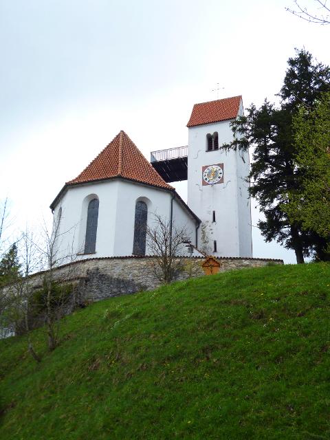

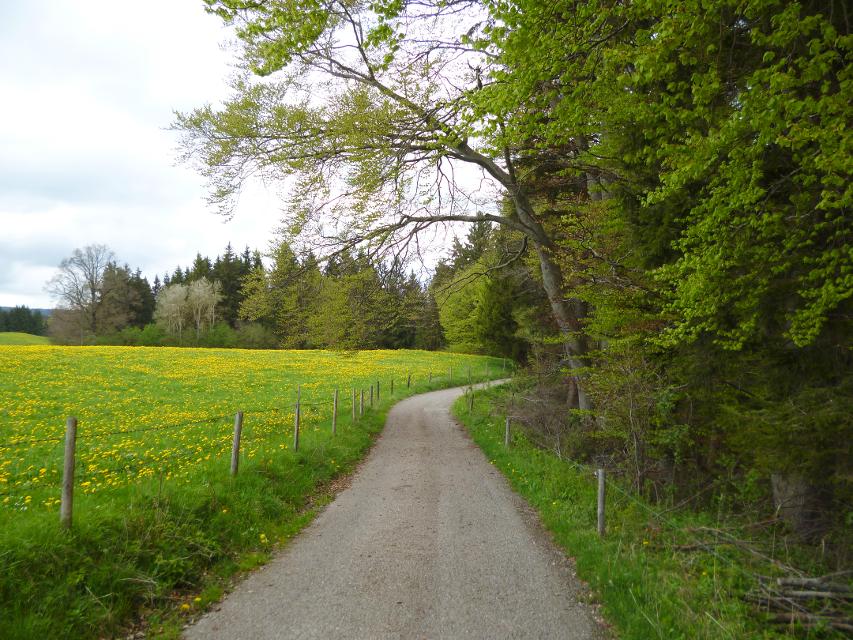


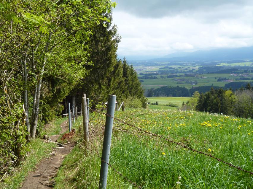
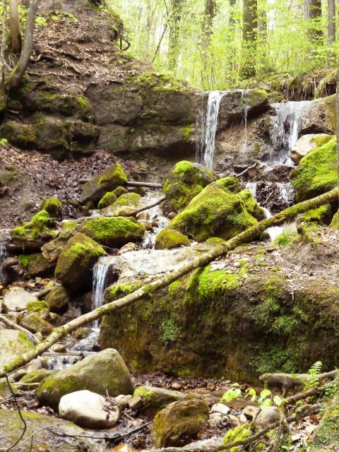
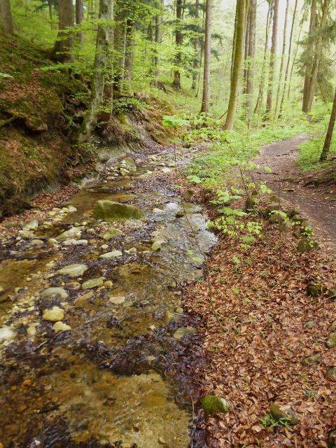
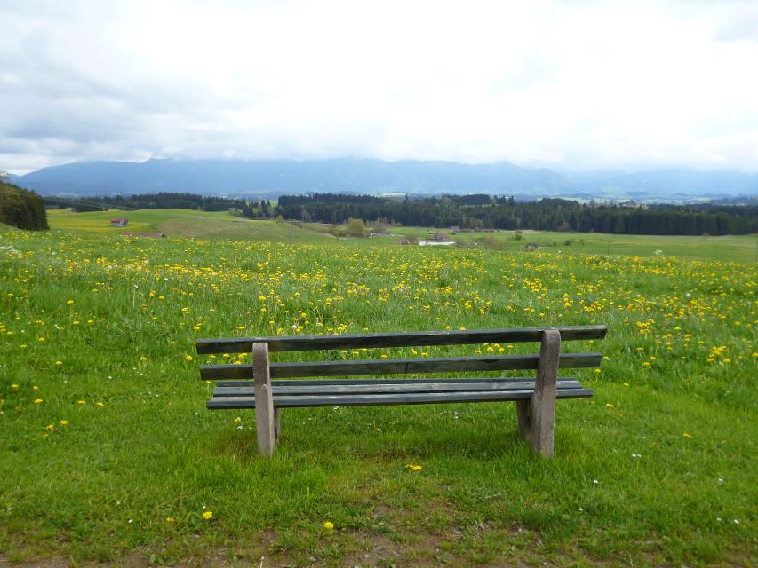


Die abwechslungsreiche Strecke vom Auerberg nach Burggen beginnt mit einem spannenden Abstieg über den Jägersteig und die wildromantische Feuersteinschlucht nach Bernbeuren. Durch weite Wiesen und Felder wandern wir später auf ruhigen Wegen in Richtung Burggen.
-
Aufstieg: 177 hm
-
Abstieg: 467 hm
-
Länge der Tour: 13,5 km
-
Höchster Punkt: 1044 m
-
Differenz: 335 hm
-
Niedrigster Punkt: 709 m
Schwierigkeit
sehr leicht
Kondition
leicht
Panoramablick
mittel
Saisonale Eignung
-
JAN
-
FEB
-
MRZ
-
APR
-
MAI
-
JUN
-
JUL
-
AUG
-
SEP
-
OKT
-
NOV
-
DEZ
Merkmale Touren
Fernwanderweg
Einkehrmöglichkeit
Parkplatz auf dem Auerberg.
Aus Richtung Westen: Auf der A7 bis zur Ausfahrt Kempten und weiter über die B12 in Richtung Marktoberdorf/Kaufbeuren. Die B12 an der Ausfahrt Marktoberdorf-West verlassen. Nun auf der B16 in Richtung Füssen bis zur Ausfahrt Stötten/Bernbeuren. Von Stötten der Beschilderung zum Auerberg folgen.
Aus Richtung Osten: Auf der A95 bis zum Autobahnkreuz Dreieck Starnberg. Hier auf die A952 wechseln. Vom Autobahnende bei Percha über die B2 nach Weilheim i. Oberbayern. Weiter über die St2058 und B472 nach Schongau. Nun der B472 in Richtung Marktoberdorf folgen, bis kurz hinter Schongau die WM3 abzweigt, die über Burggen nach Bernbeuren führt. Von Bernbeuren der Beschilderung zum Auerberg folgen.
Mit öffentlichen Verkehrsmitteln:
Anreise zu Beginn der 4. Etappe: Wegbeschreibung vom Bahnhof Schongau zum Ausgangspunkt der 4. Tagesetappe: Mit dem Bus 9821 vom Bahnhof Schongau aus nach Bernbeuren, Haltestelle Schnitzer. Von dort aus Kaufbeurer Straße einbiegen. Nach circa 100m links in die Mühlengasse einbiegen. Nach circa 150m rechts in die Auerbergstraße einbiegen und der Straße bergauf bis auf den Auerberg folgen. Dort beginnt die 4. Tagesetappe.
Abreise am Ende der 4. Etappe: Wegbeschreibung von der Endstation der 4. Tagesetappe zum Bahnhof Schongau: Am Endpunkt der 4. Tagesetappe die Straße „Lechhalde“ links gehen bis diese nach circa 400m auf die Schwarzkreuzstraße trifft. Links einbiegen. Nach circa 250m an der Straßenkreuzung links in den Sportplatzweg einbiegen. Nach circa 50m die nächste Straßenkreuzung geradeaus in die Füssener Straße überqueren. Nach circa 100m erreichen Sie an der rechten Straßenseite den Dorfbrunnen und somit die Bushaltestelle. Von dort mit der Buslinie 9821 von Burggen zum Bahnhof Schongau fahren.
Startpunkt: Auerberg
Ziel: Burggen (außerhalb am Abzweig zur Litzauer Schleife)
Navigation starten:


Hier befindet sich auch


Essen in der Nähe
"Essen in der Nähe" überspringen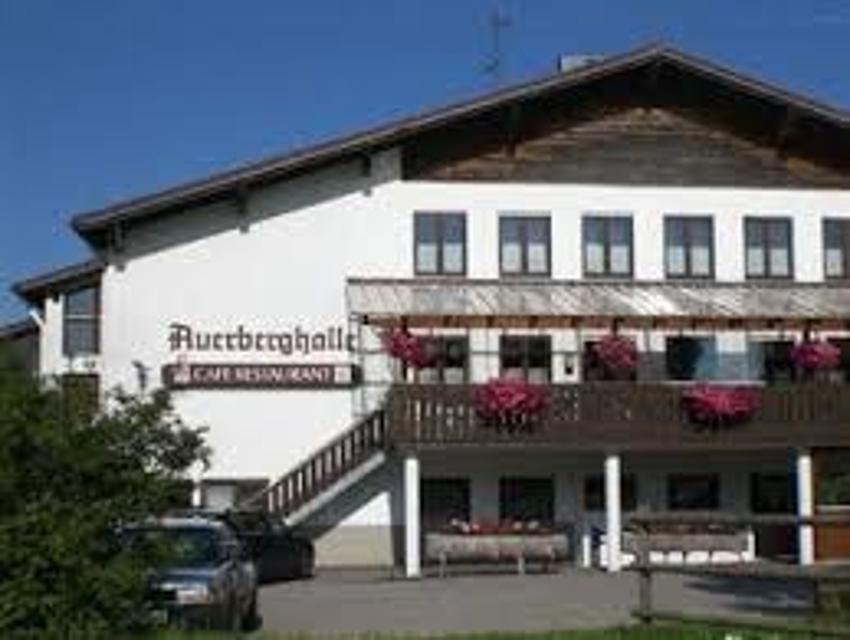

ca. 3,2 km entfernt

ca. 6,9 km entfernt
Hofcafä Burggen
Ziegler 2, 86977 Burggen, Germany
Das ist ja cool! Das ist meist die erste Reaktion von Radlern und Wanderern, die „zufällig“ amHofcafä vorbeikommen. Da steht ein Bauwagen mit herrlich einladenden Tischen und Sonnenschirmenam Hof. Und im Bauwagen? Selbstbedienung. Und zwar nur vom Feinsten!

ca. 7,7 km entfernt
Gasthaus zur Illach
Illach 1, 86989 Steingaden, Germany
Uriger und schöner Biergarten direkt an der Illach bei Steingaden


ca. 8,1 km entfernt
Bayerischer Weißwurst-Stadl
Flößerstraße 11, 86984 Prem, Germany
In einem gemütlichen "Weißwurst-Stadl" können Gäste frisch produzierte Weißwürste genießen.

ca. 8,4 km entfernt
Magdalena
Obere Dorfstraße 23, 86984 Prem, Germany
Ein wunderschöner Blumenladen mit einem recht großen Café lädt zum Verweilen und Genießen ein.
Unterkünfte in der Nähe
"Unterkünfte in der Nähe" überspringen
ca. 2,7 km entfernt


ca. 3,1 km entfernt
Pilgerherberge Pfaffenwinkel
Bayernstraße 4, 86975 Bernbeuren, Deutschland


ca. 7,5 km entfernt
Ferienwohnung Sebastian Gerstner
Röthenbachstraße 34a, 86984 Prem, Deutschland


ca. 7,9 km entfernt


ca. 8,2 km entfernt
Wohnmobilstellplatz Burggen
Auf der Burg, 86977 Burggen, Germany
Der Wohnmobilstellplatz in Burggen befindet sich im Hof der Gaststätte Fichtl und bietet 5 - 6 Wohnmobilen einen herrlichen Blick auf die Alpen. Der Gasthof bietet gutbürgerliche und auch vegetarische Küche, sowie einen herrlichen Biergarten mit Blick auf die Alpen.


Weitere Tipps in der Nähe
"Weitere Tipps in der Nähe" überspringen


ca. 0,9 km entfernt
Erlebnisstation 6 - Alpenpanorama
Germany
Dort, wo der Jägersteig auf den Auerberg am Waldrand entlang verläuft, eröffnet sich ein herrlicher Blick über die Höfe von Sennhof und das malerische Alpenvorland hinweg zu den Ammergauer und Allgäuer Alpen. Eine große Panoramatafel hilft, sämtliche sichtbare Gipfel zu erkennen und vor allem mit dem richtigen Namen zu benennen.
Das könnte Dir auch gefallen
"Das könnte Dir auch gefallen" überspringen
Etappe 2, Westschleife, Heilige Landschaft Pfaffenwinkel - Von Rottenbuch nach Steingaden
Auf dem Weg von Rottenbuch nach Steingaden erwarten uns herausragende kulturelle Sehenswürdigkeiten. Unterwegs werden die Lourdes-Grotte in Wildsteig und die weltberühmte, zum UNESCO-Welterbe zählende Wieskirche passiert. Am Start- bzw. Zielpunkt lohnen die ehemalige Klosterstiftskirche und das Welfenmünster einen Besuch. Landschaftlich besonders reizvoll ist der Brettleweg durch das Wiesfilz nahe der gleichnamigen Wallfahrtskirche.
4:15 h 312 hm 314 hm 14,9 km mittel

Etappe 3, Westschleife, Heilige Landschaft Pfaffenwinkel - Von Steingaden zum Auerberg
Ausgesprochen aussichtsreich führen uns die größtenteils gut ausgebauten Wege von Steingaden bis auf den Auerberg mit der weithin sichtbaren St. Georgs Kirche. Nachdem wir zunächst noch idyllisch entlang des Urspringer Lechstausees wandern, genießen wir auf dem Weg von Lechbruck in Richtung Auerberg fast durchgehend ein fantastisches Bergpanorama.
5:30 h 493 hm 212 hm 17,9 km sehr schwer

Etappe 5, Westschleife, Heilige Landschaft Pfaffenwinkel - Von Burggen nach Schongau
Auf dem Weg von Burggen nach Schongau mit seiner mittelalterlichen Altstadt erwartet uns mit der Litzauer Schleife östlich von Burggen ein landschaftlicher und mit der Romanischen Basilika in Altenstadt ein historisch-kultureller Höhepunkt des westlichen Pfaffenwinkels.
3:30 h 134 hm 178 hm 12,6 km sehr leicht

Etappe 1, Nordschleife, Heilige Landschaft Pfaffenwinkel - Vom Hohen Peißenberg nach Paterzell
Die erste Etappe der Nordschleife des Fernwanderwegs Heilige Landschaft Pfaffenwinkel führt uns vom Hohen Peisenberg nach Paterzell, durch dichte Wälder, verwunschene Moorlandschaften und vorbei an zahlreichen Kirchen, Kapellen und Bildstöcken. Schon hier wird uns bewusst, wie der Pfaffenwinkel zu seinem Namen kam. Wir bestaunen die barocke Kirche bei St. Leonhard im Forst, die majestätische "Alte Linde" bei Linden und wandern durch einen malerischen Wald mit der Ulrichsquelle bis Paterzell, das das Ziel unseres Weges markiert.
3:30 h 153 hm 487 hm 12,1 km mittel

Etappe 1, Ostschleife, Heilige Landschaft Pfaffenwinkel - Vom Hohen Peißenberg nach Weilheim
Die erste Etappe der Ostschleife des Fernwanderwegs Heilige Landschaft Pfaffenwinkel führt uns vom Hohen Peißenberg nach Weilheim in Oberbayern. Wir durchqueren die sanfte Hügellandschaft des Voralpenlandes und genießen herrliche Ausblicke auf das Alpenmassiv. Auf dem Weg kommen wir an mehreren Kapellen vorbei, wandern an der Ammer entlang und können wir die Kirchen Peißenbergs und Pollings bestaunen.
5:10 h 66 hm 466 hm 18,8 km mittel

Etappe 3, Nordschleife, Heilige Landschaft Pfaffenwinkel - Von Raisting nach Herrsching
Die dritte Etappe des Fernwanderwegs Heilige Landschaft Pfaffenwinkel führt uns von Raisting über Fischen an den Ammersee. Ein bisschen Zeit sollte man auf dem Weg von Raisting an den Ammersee schon einplanen, denn neben der eindrucksvollen Landschaft, die vor allem durch die weitläufigen Ammerwiesen, die Ammer selbst und natürlich dem Ammersee geprägt ist, gibt es auch einige Bauwerke und Museen zu besichtigen. So befinden sich zum Beispiel in Sölb die schöne Filialkirche St. Margareta, in Fischen die Maria-Hilf-Kapelle und das Kupfermuseum, in dem die Geschichte des Kupferhandwerks bestaunt werden kann, und kurz vor Herrsching schließlich da barocke Schloss Mühlfeld. Erholung bieten die zahlreichen Strandcafés am Ammersee. Hier kann man die Seele einfach mal baumeln lassen.
4:30 h 54 hm 74 hm 14,9 km mittel

Etappe 4 (eilig), Ostschleife, Heilige Landschaft Pfaffenwinkel - Von Penzberg (Promberg) nach Iffeldorf
Wir starten die vierte Etappe des Fernwanderweges Heilige Landschaft Pfaffenwinkel in Promberg bei Penzberg. Auf dieser Etappe passieren wir den Stadtkern Penzbergs ehe wir nach Iffeldorf an den Osterseen kommen.
4:15 h 130 hm 150 hm 15,2 km mittel


König-Ludwig-Weg, 3. Etappe: Paterzell - Hohenpeißenberg
3:44 h 409 hm 333 hm 12,8 km sehr schwer

König-Ludwig-Weg, 5. Etappe, Variante: Rottenbuch - Trauchgau
5:22 h 243 hm 218 hm 20,5 km mittel


König-Ludwig-Weg, 6. Etappe, Variante: Trauchgau - Füssen
6:01 h 332 hm 332 hm 22,3 km mittel


LechErlebnisWeg
Wandern Sie durch die herrliche Fluss- und Seenlandschaft des Lechs. Natürliche Flussabschnitte, spiegelnde Seen, gemütliche Ortschaften und die historischen Altstädte von Landsberg, Schongau und Füssen bilden die malerische Kulisse dieses Fernwanderweges.
23:00 h 769 hm 496 hm 86,7 km mittel


Etappe 3, Ostschleife, Heilige Landschaft Pfaffenwinkel - Von Bernried nach Penzberg-Promberg
Die dritte Etappe der Ostschleife des Fernwanderwegs Heilige Landschaft Pfaffenwinkel führt uns von Bernried nach Promberg bei Penzberg. Das Highlight dieser Etappe ist der Weg entlang des Starnberger Sees. Wir genießen einen grandiosen Weitblick auf den See und das Alpenmassiv.
3:45 h 122 hm 98 hm 14,3 km mittel

Etappe 4, Nordschleife, Heilige Landschaft Pfaffenwinkel - Von Herrsching über Andechs nach Pähl
Von Herrsching wandern wir auf der vierten Etappe des Fernwanderwegs Heilige Landschaft Pfaffenwinkel durch das Kiental, eine bis zu 70m tief eingeschnittene Nagelfluhschlucht zum Kloster Andechs. Auf dem Weg nach Andechs tauschen wir das flache Gelände des Ammersees wieder gegen Wald, Wiesen und leichte Hügel. Man sollte sich genug Zeit nehmen, um das berühmte Kloster Andechs zu besichtigen und in der Klosterschänke einen guten Tropfen Bier und leckere regionale Schmankerl zu genießen. Die Geschichte des Klosters geht zurück bis in zehnte Jahrhundert und es ist dank aufwendiger Restaurierungsarbeiten heute noch sehr gut erhalten. Schweren Herzens sagen wir den Leckereien aus der Klosterküche Lebwohl, denn die Strecke führt uns weg vom Kloster Andechs und weiter nach Pähl. Der Ausblick über den Ammersee und die hügelige Landschaft des Pfaffenwinkels, die wir auf dem Weg erleben dürfen, entschädigt dafür aber allemal. Auch die kleine Hartkapelle, deren Geschichte einem kleinen Krimi gleicht und das Gut Kerschlach mit Hofladen, Bäckerei/Café und einem schön angelegten Klostergarten sind Highlights auf dem Weg. In Pähl selbst vor allem die St. Laurentius-Kirche sehenswert.
7:00 h 234 hm 187 hm 16,2 km mittel

Etappe 5, Nordschleife, Heilige Landschaft Pfaffenwinkel - Von Pähl nach Weilheim
Puste ist gefragt - die 21 km der fünften Etappe von Pähl über Wilzhofen und Marnbach nach Weilheim fordern unsere Ausdauer. Dafür werden wir mit vielen schönen Ausblicken über die herrliche Hardtlanschaft und teilweise bis zu den Alpen, Sehenswürdigkeiten sowie grünen Wäldern und Wiesen belohnt. Architektonische Highlights erwarten uns in Weilheim, darunter die Pfarrkirchen Mariä Himmelfahrt und St. Pölten und der Marienplatz sowie die gut erhaltene Stadtmauer. Auch das sogenannte "Museum des Pfaffenwinkels" ist ein Besuch wert. Dort werden Exponate der Region präsentiert und die Geschichte des Pfaffenwinkels näher beleuchtet.
7:00 h 305 hm 322 hm 21,3 km mittel

Etappe 5, Ostschleife, Heilige Landschaft Pfaffenwinkel - Von Benediktbeuern nach Iffeldorf
Die fünfte Etappe des Fernwanderwegs Heilige Landschaft Pfaffenwinkel Ostschleife führt uns von Benediktbeuern nach Iffeldorf. Auf dieser Etappe bestaunen wir das Kloster Benediktbeuern, die Heuwinklkapelle und die Kirche St. Vitus in Iffeldorf. In Penzberg wandern wir im Erholungsgebiet Berghalde auf den Spuren des Bergbaus und erfahren Wissenswertes zur Geschichte der Stadt Penzberg.
5:15 h 262 hm 277 hm 20,8 km sehr schwer

Etappe 6, Nordschleife, Heilige Landschaft Pfaffenwinkel - Von Weilheim nach Peißenberg
Die sechste Etappe des Fernwanderwegs Heilige Landschaft Pfaffenwinkel Nordschleife führt uns von Weilheim nach Peißenberg. Falls wir nach der langen fünften Etappe keine Zeit mehr hatten, Weilheim zu besichtigen, so lässt uns die nicht ganz so lange, sechste Etappe dafür genug Zeit im Vorfeld noch durch die Fußgängerzone und über den Marienplatz zu flanieren, die Stadtpfarrkirche Mariae Himmelfahrt zu besuchen und die Kirche St. Pölten - die älteste Weilheimer Kirche, deren Ursprünge bis ins 8. Jh. zurück gehen zu bestaunen. Danach machen wir uns auf den Weg nach Peißenberg. Unterwegs treffen wir erneut auf die Ammer und können in Polling das sehenswerte Klosterdorf (Kloster Heilig Kreuz) und die Stiftskirche St. Salvator der Augustiner Chorherren besuchen.
3:45 h 157 hm 141 hm 12,4 km mittel

Etappe 7, Nordschleife, Heilige Landschaft Pfaffenwinkel - Von Peißenberg auf den Hohen Peißenberg
Die letzte Etappe des Fernwanderwegs Heilige Landschaft Pfaffenwinkel führt uns über eine kurze, aber dennoch anstrengende Strecke zurück zu unserem Ausgangspunkt auf dem Hohen Peißenberg. Frische Beine sind beim Aufstieg zum Hohen Peißenberg sicher nicht schlecht, allerdings nicht unbedingt ein Muß, denn die knapp 6 km und 400 hm kann man auch ganz gemütlich angehen. Je höher wir kommen umso besser wird der Ausblick über den Pfaffenwinkel und wir können noch einmal die Region überblicken, die wir in den letzten Tagen zu Fuß erkunden konnten.
3:15 h 397 hm 3 hm 7,0 km mittel

Etappe 8, Ostschleife, Heilige Landschaft Pfaffenwinkel - Von Peißenberg zum Hohen Peißenberg
Die achte und letzte Etappe der Ostschleife des Fernwanderwegs Heilige Landschaft Pfaffenwinkel führt uns von Peißenberg auf den Hohen Peißenberg. Wir wandern auf abwechslungsreichen und wenig befahrenen Wegen auf den Aussichtsberg des Pfaffenwinkels, wo wir das Ziel des Fernwanderwegs erreichen.
4:00 h 409 hm 40 hm 8,9 km sehr schwer


König-Ludwig-Weg, 4. Etappe: Hohenpeißenberg - Rottenbuch
Diese Tagesetappe sorgt für ungeante Natureindrücke. Bitte die Sicherheitshinweise beachten!
3:45 h 191 hm 201 hm 12,8 km sehr schwer

Etappe 2, Ostschleife, Heilige Landschaft Pfaffenwinkel - Von Weilheim nach Bernried
Die zweite Etappe des Fernwanderwegs der Ostschleife Heilige Landschaft Pfaffenwinkel führt uns von Weilheim in Oberbayern nach Bernried. Weitläufige Moor- und Sumpfgebiete, idyllische Seen und malerische Wälder begleiten den Weg zum Starnberger See. Auf dieser Etappe führen uns die Vielzahl an Kapellen und Kirchen vor Augen, wie der Pfaffenwinkel zu seinem Namen kam.
5:45 h 212 hm 181 hm 22,5 km mittel