-
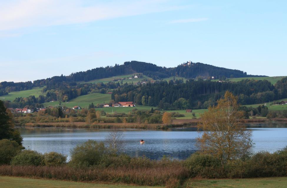
Aufstieg: 105 hm
-
Abstieg: 103 hm
-
Länge der Tour: 7,6 km
-
Höchster Punkt: 809 m
-
Differenz: 60 hm
-
Niedrigster Punkt: 749 m
Schwierigkeit
mittel
Kondition
mittel
Panoramablick
mittel
Saisonale Eignung
-
JAN
-
FEB
-
MRZ
-
APR
-
MAI
-
JUN
-
JUL
-
AUG
-
SEP
-
OKT
-
NOV
-
DEZ
Merkmale Touren
Aussichtsreich
Rundweg
Bernbeuren Ortsmitte oder Sportplatz
Parkplätze vorhanden


Hier befindet sich auch
 }
}
St. Nikolaus, Bernbeuren
Marktplatz, 86975 Bernbeuren, Germany
Die im Stil des Barock gebaute Bernbeurer Pfarrkirche ist dem Schutzheiligen der Flößer, dem heiligen Nikolaus, geweiht.
 }
}
 }
}
Das könnte Dir auch gefallen
"Das könnte Dir auch gefallen" überspringen }
}
Antdorfer Betbichlrunde
Auf dieser Tour wird deutlich, wie der Pfaffenwinkel zu seinem Namen kam. Die idyllische "Betbichlrunde" führt über eine Mariengrotte zur Kirche nach Frauenrain und weiter über den Kirnberg mit seiner Kapelle. Auf dieser gemütlichen Hügelrunde können die Baudenkmäler besichtigt werden und den Naturliebhaber begleitet ein grandioser Weitblick auf das Alpenmassiv.
0:45 h 62 hm 57 hm 2,9 km sehr leicht
 }
}
 }
}
 }
}
Kleiner Lauterbacher Waldweg
Ruhige Wald- und Forstwege führen durch das idyllische Moorgebiet nördlich und die ausgedehnten Wälder westlich des Großen Ostersees. Tief im Lauterbacher Wald versteckt liegt außerdem die sagenumwobene Pollingsrieder Kapelle. Auf den wenigen Abschnitten über freie Wiesen und Felder genießen Spaziergänger ein grandioses Bergpanorama. Beschildert: Nr. 22, rot
3:30 h 218 hm 218 hm 13,8 km mittel
 }
}
Lechrunde
Die Lechrunde führt direkt von Bernbeuren an den Lech mit der Staustufe Nr. 4 (ab Forggensee) bei Dessau. Im ersten Wegabschnitt passiert man linker Hand das Golf-Übungsgelände Stenz, der Rückweg führt ohne große Anstiege südlich über Grönenbach. Unten am Lech Anschlußmöglichkeit auf dem Lech-Uferweg nach Lechbruck (Süden) und Burggen (Norden).
2:28 h 81 hm 81 hm 9,6 km mittel
 }
}
 }
}
Durch Berg und Tal
Die ausgedehnte Runde um Oberhausen und Huglfing macht ihrem Namen alle Ehre. In stetem Auf und Ab geht es durch die wunderschöne, weitläufige Wiesen-, Moor- und Hügellandschaft im südlichen Pfaffenwinkel. Immer wieder genießen Spaziergänger ein traumhaftes Alpenpanorama. Beschildert Nr. 61, rot
3:15 h 197 hm 197 hm 12,2 km mittel
 }
}
Großer Lauterbacher Waldweg
Teils auf ruhigen Forstwegen, teils auf kaum befahrenen Asphaltsträßchen durchstreifen Spaziergänger die sanfte Hügellandschaft nordwestlich des Großen Ostersees. Auch wenn die ausgedehnte Wanderung über weite Strecken durch dichte Wälder führt, bieten sich immer wieder wunderschöne Blicke auf die Alpenkette. Beschildert: Nr 21, rot
4:30 h 264 hm 264 hm 17,4 km mittel
 }
}
 }
}
Schnalz-Panoramaweg Böbing
Abwechslungsreicher könnte der bergige Rundweg kaum sein. Gut ausgebaute Panoramastrecken bieten am Anfang und Ende viel Zeit zum Schauen und Genießen. Dazwischen erwarten Wanderer mitunter steile Wurzel- und Treppenpfade durch den Wald, die bis hinunter an die Ammer und bis hinauf auf den Schnalz-Gipfel (901 m) führen. Beschildert: Nr. 89, blau
2:30 h 350 hm 350 hm 7,7 km mittel
 }
}
 }
}
Sonnenbichl-Weg
Der Sonnenbichl-Weg ist eine erstklassige Panoramarunde. Bis auf wenige Abschnitte werden Spaziergänger auf der gesamten Strecke von einem grandiosen Bergblick begleitet. Vom Aussichtspunkt in Geigersau, der nicht umsonst Dreiseenblick genannt wird, eröffnet sich ein eindrucksvoller Blick nach Norden bzw. Osten auf Ammersee, Starnberger See und Staffelsee. Beschildert: Nr. 93, blau
2:30 h 175 hm 151 hm 10,0 km mittel
 }
}
Alpenblick-Wanderung
Raisting liegt in Oberbayern in unmittelbarer Nähe zum Ammersee. Die Erdfunkstelle ist das Wahrzeichen der Gemeinde, die schon von weitem zu sehen ist. Die Alpenblick-Wanderung welche mit der Nr. 52 auf grünem Grund beschildert ist, belohnt die Spaziergänger nicht nur mit einem herrlichen Weitblick auf das Alpenmassiv, sondern auch mit einem Blick auf die Erdfunkstelle. Beschilderung: Nr. 52, grün
1:15 h 53 hm 53 hm 4,7 km sehr leicht
 }
}
 }
}
Doktor-Faustus-Weg
Der Doktor-Faustus-Weg wurde nach den Ortsbeschreibungen im Roman angelegt, die durch Thomas und Viktor Mann eindeutig für Polling verbürgt sind. Der landschaftlich reizvolle Rundweg berührt alle Orte, die Thomas Mann im Zusammenhang mit Geburts- und Wohnort seiner Titelfigur Adrian Leverkühn erwähnt. Man wandert auf den Spuren eines bedeutenden Werkes der Weltliteratur - im Spannungsfeld zwischen Realität und Kunstfigur. Mit 13 Texttafeln bietet der Themenweg unterhaltsame Erholung in intakter Kulturlandschaft.
1:30 h 60 hm 60 hm 4,6 km sehr leicht
 }
}
Enzianweg
Der landschaftlich reizvolle Rundweg hat allerlei Abwechslung zu bieten: weitläufige Wiesen, Felder und Moore, ein idyllisch gelegener See, ein erfrischender Badeweiher, zwei malerische Kapellen und nicht zuletzt ein fantastisches Bergpanorama. So geht es auf ruhigen, größtenteils asphaltierten Wegen genussvoll durch die wunderschöne Landschaft nordöstlich von Obersöchering. Beschildert: Nr. 11, blau
2:00 h 22 hm 22 hm 8,5 km sehr leicht
") }
}
Hardtrunde (kurz)
Die kurze Version der Hardtrunde streift die typische Hardtlandschaft östlich von Weilheim nur am Rande. Im Zentrum steht vielmehr das sanfte Hügelland rund um den idyllischen Dietlhofer See, einem beliebten Badesee im Norden von Weilheim. Immer wieder genießen Spaziergänger wunderschöne Ausblicke auf den See und den Weiler Dietlhofen. Beschildert: Nr. 42, grün
1:00 h 47 hm 47 hm 3,9 km sehr leicht
 }
}
Höllfilzweg
Die Gemeinde Antdorf in Oberbayern besticht mit ihrer traumhaften Lage nahe der Osterseen und unweit von Penzberg. Wenig frequentierte Wanderwege und Wiesenpfade sorgen auf dem gemütlichen Spazierweg für Erholung in der pfaffenwinkler Landschaft. Grüne Sommerwiesen vor einem prächtigen Alpenpanorama, historische Kirchen und eine kleine Kapelle versprechen Wandervergnügen im Voralpenland. Beschildert: Nr. 7, blau
2:15 h 85 hm 85 hm 8,4 km mittel
 }
}
Illach-Rundweg
Der flache Rundweg nahe der Illach führt Wanderer durch die weitläufige Landschaft des Pfaffenwinkels. Während Kulturinteressierte in Steingaden die Spuren der Welfendynastie erforschen können, ist für Naturliebhaber der türkisfarbene Lechstausee eine wunderbare Sehenswürdigkeit. Ausgeschildert mit der Nr. 120, rot.
2:30 h 154 hm 154 hm 9,4 km mittel
 }
}
 }
}
Klosterweiher-Weg
Der Klosterweiherweg ist eine ausgedehnte und idyllische Runde in der typischen Moränenlandschaft um Bernried. Die fünf Weiher, die dieser Weg verbindet. entstanden in einer wirtschaftlichen Verbindung zu dem früheren Kloster der Augustinerchorherren und sind heute schöne Orte der Meditation.
4:30 h 139 hm 144 hm 13,3 km mittel
 }
}
Königssträßle-Rundweg
Die panoramareiche Runde führt auf ruhigen Wegen durch die hügelige Voralpenlandschaft des südlichen Pfaffenwinkels. Grandiose Bergblicke und die weit über die Grenzen Bayerns hinaus bekannte Wieskirche ziehen Spaziergänger in ihren Bann. Beschildert: Nr. 117, blau
2:30 h 173 hm 173 hm 9,8 km mittel
 }
}
Kultur - Ammerschlucht
Die Tour führt über Stufen, Stege und Brücken durch die ungebändigte Ammerschlucht und durch wildromantische Mischwälder. Der Weg entlang der Schlucht und der Pfad an der Reitnerbachklamm fordern die Trittsicherheit der Wanderer. Die zum Teil herausfordernden Wege werden mit außergewöhnlichen Ausblicken belohnt. Beschildert: Nr. 88, rot
6:00 h 211 hm 211 hm 21,1 km mittel
 }
}
Lanzenbachweg
Idyllisch führt die Runde, die auf den Schildern mit der Nr. 8 auf blauem Grund zu finden ist, in stetem Auf und Ab durch die Wald- und Wiesenlandschaft östlich des Pollinger Weihers. Immer wieder genießen Spaziergänger traumhafte Ausblicke auf die Alpenkette. Im Reinthaler Bauernhofmuseum können allerlei alte landwirtschaftliche Geräte bestaunt werden. Direkt nebenan lohnt sich eine Einkehr im dazugehörigen Café. Beschildert: Nr. 8, blau
2:15 h 128 hm 128 hm 8,6 km mittel
 }
}
Lauterbach-Rundweg
In Steingaden beginnt der Rundweg nach Lauterbach. Vom Startpunkt führt der Weg über wenig befahrene Sträßchen und Forstwege nordöstlich von Steingaden. Ein Begleiter der Tour ist der grandiose Weitblick auf die Alpen und auf das Welfenmünster. Ausgeschildert ist der Weg mit der Nr. 119, blau.
2:15 h 142 hm 142 hm 7,3 km mittel
 }
}
 }
}
Moor- und Drumlinrunde Eberfing
Die ausgedehnte Spazierrunde bei Stadel ist eine Runde durch die weitläufigen Filzgebiete und romantische Wälder im bayerischen Oberland nahe des Starnberger Sees. Auf der Rundwanderung darf man die sanfte Hügellandschaft im malerischen Voralpenland kenne lernen. Der Stadler Weiher ist das Highlight der Tour und einen Abstecher für einen Sprung in das kühle Nass wert. Beschildert: T16, blau
2:30 h 60 hm 58 hm 8,2 km mittel
 }
}
Naturwunder-Tour
Über grüne Wiesen, flache Hügel und ruhige Wälder zum Naturschutzgebiet Litzauer Schleife. Hier ist Lech nahezu unberührt und bietet vielen Pflanzen und Tieren einen einzigartigen Lebensraum. Atemberaubende Aussichten inklusive. Beschildert: B2, grün
2:05 h 59 hm 59 hm 8,1 km sehr leicht